Grainger

A Portion of Map Printed in 1795 showing Blount County

Early History of Blount County, Tennessee

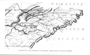
Blount County was created out of Knox County by an act passed at the second session of the territorial assembly at Knoxville, on July 11, 1795, and named in honor of William Blount, the first and only territorial governor. Knox County had been created from fractions of Greene and Hawkins counties in 1792. Greene was created from Washington in 1783, and Washington was established in 1777, the oldest county in the state. Since the creation of Blount County in 1795, the territorial limits have been added to by the Treaty of Tellico, 1798, and Calhoun’s Treaty of 1819. A portion […]

Early History of Blount County, Tennessee Read More »

History of Blount County Tennessee

Blount County Tennessee lies between the Tennessee River and the great Smoky Mountain, and south of Knox County. It has an area of about 470 square miles, one-sixth of which is mountain land. It is abundantly supplied with water and water power. The principal stream is Little River, which receives the waters of Crooked Creek, Pistol Creek, Nails Creek and Ellejoy. In the southern and western portions of the county are Abram, Nine Mile, Six Mile, Four Mile, Baker and Boyd Creeks. The mineral resources are abundant. In addition to iron and marble. silver and gold are found in paying

History of Blount County Tennessee Read More »

Scroll to Top