Lackey

Pleasant Grove Cemetery, Lenoir City, Tennessee

The Pleasant Grove Cemetery is also known by the name of Crandall Cemetery. From the intersection of Interstate 75 and Highway 95, travel east on Highway 95 for about 0.4 miles and turn left onto Town Creek Road. Travel on Town Creek Road for about 0.4 miles and turn left onto Shaw Ferry Road. Travel on Shaw Ferry Road for about 0.1 miles. The cemetery is on the right. There are many unmarked graves. Listed by Robert L. Bailey, 2 Apr 1988. Surname First Name Birth Death Remarks ALEXANDER Andrew H. 25 Oct 1824 21 Aug 1826 s/o L. & […]

Pleasant Grove Cemetery, Lenoir City, Tennessee Read More »
Blount County Tennessee Chancery Court Records 1850 – 1900s

The government of Blount County, Tennessee has created an index for their Chancery Court records covering the years of 1850-1900s. These records are stored in twenty-nine boxes with an archives copy stored on microfilm. This index is reproduced below in a searchable format. Click here to see their pdf version of this index. Chancery court cases contain records of equity cases, some divorces, estate disputes and other private suits.

Blount County Tennessee Chancery Court Records 1850 – 1900s Read More »

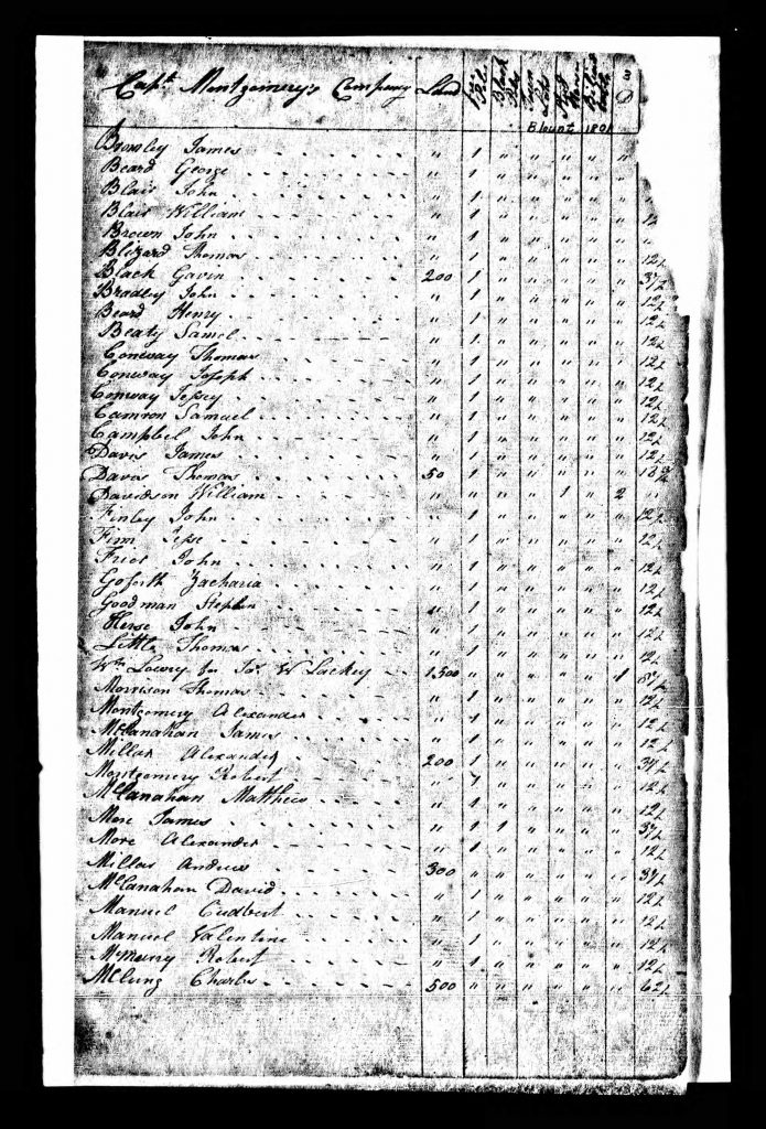
Blount County TN 1801 Tax List - Page 03

Tax rate of Captain Montgomery’s Company for the Year 1801

There are two additional columns in the original entitled “Billiard Tables” and “Stud Horses.” No individuals were listed as owning any of the former, and only two individuals of Montgomery’s Company were designated as owning any of the latter: William Davidson had 2 and Meshech Tipton had 1. Name Land Free Polls Black Polls Town Lots Bromley, James 1 Beard, George 1 Blair, John 1 Blair, William 1 Brown, John 1 Blizard, Thomas 1 Black, Gavin 200 1 Bradley, John 1 Beard, Henry 1 Beaty, Samel 1 Conway, Thomas 1 Conway, Joseph 1 Conway, Jessey 1 Camron, Samuel 1 Campbel,

Tax rate of Captain Montgomery’s Company for the Year 1801 Read More »

History of Blount County Tennessee

Blount County Tennessee lies between the Tennessee River and the great Smoky Mountain, and south of Knox County. It has an area of about 470 square miles, one-sixth of which is mountain land. It is abundantly supplied with water and water power. The principal stream is Little River, which receives the waters of Crooked Creek, Pistol Creek, Nails Creek and Ellejoy. In the southern and western portions of the county are Abram, Nine Mile, Six Mile, Four Mile, Baker and Boyd Creeks. The mineral resources are abundant. In addition to iron and marble. silver and gold are found in paying

History of Blount County Tennessee Read More »

Scroll to Top