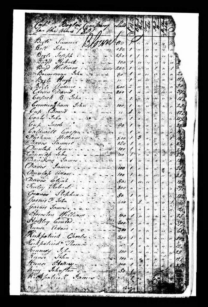
Sims

Anderson County Deed Index: 1846-1847

Anderson County Deed index provides a full index of all people named in Anderson County, Tennessee deeds for the years of 1846 – 1847 as found in volume M, Register of Deeds. These deeds were microfilmed by the Tennessee State Archives on roll #31. Number Name Type Date 138 Adamson, Solomon indenture 1847 18 Adkins, Richard deed 1846 19 Adkins, Richard indenture 1846 32 Aldridge, Joseph indenture 1846 33 Aldridge, Joseph indenture 1846 132 Alldred, Joseph bill of sale 1847 90 Alldredge, Joseph bill of sale 1847 159 Altom, Spencer indenture 1847 143 Ambrose, Bats indenture 1847 60 Ayers, Jesse

Anderson County Deed Index: 1846-1847 Read More »

Blount County TN 1801 Tax List - Page 01

Tax Rate of Captain Bogle’s Company for the Year 1801

There are two additional columns in the original entitled “Billiard Tables” and “Stud Horses.” No individuals were listed as owning any of the former, and only two individuals of Bogle’s Company were designated as owning any of the latter: William Boyd and Michel Nyman. Name Land Free Polls Black Polls Town Lots Bogle, Samuel 150 1 Bell, John 150 1 Bogle, Joseph 150 1 1 Boyd, Robert 150 1 Boyd, William 200 1 Bowerman, John 30 1 Bogle, Hugh 200 1 Bogle, Andrew 200 2 Carson, David 200 1 Cusack [Cusick], John B. 1 Cunningham, John 100 1 Cup [Cupp],

Tax Rate of Captain Bogle’s Company for the Year 1801 Read More »

A Portion of Map Printed in 1795 showing Blount County

Early History of Blount County, Tennessee

Blount County was created out of Knox County by an act passed at the second session of the territorial assembly at Knoxville, on July 11, 1795, and named in honor of William Blount, the first and only territorial governor. Knox County had been created from fractions of Greene and Hawkins counties in 1792. Greene was created from Washington in 1783, and Washington was established in 1777, the oldest county in the state. Since the creation of Blount County in 1795, the territorial limits have been added to by the Treaty of Tellico, 1798, and Calhoun’s Treaty of 1819. A portion

Early History of Blount County, Tennessee Read More »

History of Blount County Tennessee

Blount County Tennessee lies between the Tennessee River and the great Smoky Mountain, and south of Knox County. It has an area of about 470 square miles, one-sixth of which is mountain land. It is abundantly supplied with water and water power. The principal stream is Little River, which receives the waters of Crooked Creek, Pistol Creek, Nails Creek and Ellejoy. In the southern and western portions of the county are Abram, Nine Mile, Six Mile, Four Mile, Baker and Boyd Creeks. The mineral resources are abundant. In addition to iron and marble. silver and gold are found in paying

History of Blount County Tennessee Read More »

Scroll to Top